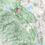
Route Tracks, Waypoints, and GPX Files
Your route is hosted on Ride With GPS. To navigate the route:
- Use your phone with the Ride With GPS app or
- Download the GPX file to your GPS device.
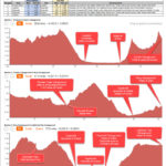
Route Resupply Notes & Profiles
This document gives you a preview of the route and helps you determine how much water and food to carry between resupply points.
The more miles and elevation gain to the next resupply, the more water and food you should carry.
Print and bring a copy it with you for quick reference during your ride. You will refer to it often.
Camping Options
These are only suggestions. If they don’t work for your trip, feel free make your own plans.
- If you decide to wild camp:
- Wild camping is allowed in National Forests, however, check alerts and notifications for closures and fire bans. Alerts and Notifications for: Tahoe, Plumas, Lassen
- If you plan to have a campfire, get a campfire permit and bring a copy of it with you.
- Also, few campgrounds have bear boxes. Therefore, you’ll need to an Ursack or another effective bear/food strategy. Do not leave food out. It leads to bears being killed for loosing their fear of humans.
- Night 1:
- Conklin Park Campground
- Facilities: No fee, vault toilet, bear boxes, NO potable water
- There is a stream that flows through the campground, however, it my be dry by the end of June
- There is no sign for this campground and it’s easy to miss the turnoff on the right because you’ll be descending as you approach it.
- Night 2:
- Roxie Penconom Campground
- Facilities: No fee, vault toilet, potable water
- If the water is off, there is a stream and river nearby
- Night 3:
- Lightning Tree Campground
- Facilities: $34, vault toilets, potable water
- During peak season, there is a campground host
- Night 1 Alternative:
- If the creek running through Conklin Park Campground is dry and/or you feel like adding another 22 miles (93 miles total for Day 1), keep going to Lone Rock Campground. It has reliable water (usually turned on Memorial weekend). As a bonus, you’ll start the big climb over to Susanville first thing in the morning.
- Lone Rock Campground
- Facilities: $32, vault toilet, potable water, and very small store with limited hours
- During peak season, there is a campground host
- This campground is about 0.5 miles off-route
- Night 2 Alternative:
- If you stayed in Lone Rock Campground on Night 1 (the alternative) and want to do another big day, consider riding to the Taylorsville Campground (85 miles; 6,900ft from Lone Rock Campground). Or if you took one of the alternate routes and skipped Susanville, this might be a good stopping point for Day 2. Taylorsville is a quaint, small town that is about 0.5 miles from the campground. It has a general store (10a-4p) and a tavern (1p-2a) that serves food and drinks.
- Taylorsville Campground
- Facilities: $14 per site, water, coin showers, bathroom
- Campground host
Getting to Truckee
Drive: If you are coming from Sacramento or the Bay Area, be aware that traffic Friday afternoon/evening is notoriously bad.
Amtrak: Amtrak has 2 trains that stop in Truckee each day (1 from the east and 1 from the west). Amtrak has reportedly become more bike friendly, but be sure to check out the details at amtrak.com. According to their booking system, they don’t “officially” let you book a bike to Truckee. The issue is that they don’t have access to the luggage car that holds your bike when they stop in Truckee. The platform is too short. However, some cyclists have had success with the following: Talk to a conductor when you get on the train and explain you want to get off in Truckee with your bike. They can move your bike to a luggage closet. That way, when they stop in Truckee, they can get your bike off the train. Worst case, you can always get off with your bike in Reno. There is a good bike route from Reno to Truckee, but can be hot in summer.
Bus: Greyhound and Amtrak (offers bus routes to Truckee) are your bus options.
Fly: Reno is the closest airport (~45 min drive) and an Uber to Truckee from RNO is about $65 (may change). After that, Sacramento is your next closest option (~90 min drive).
Staying in Truckee
Rent a house: There are lot of homes for rent in Truckee and the Tahoe Donner neighborhood. You can often get a 3 bedroom home for around $200/night through AirBnB or VRBO.
Hotel or hostel: There are a few hotels in Truckee and one hostel (~$50 for a bed in a bunk room).
Warmshowers.org: A great community of cyclists who host traveling cyclists. There are about 10 hosts in Truckee. The spirit of the site is that they host cyclists when they are actually on a trip, but some hosts might be willing to let you stay a night and leave your car parked in front of their house.
Camping: There are several campgrounds in/near Truckee. Donner State Park is the closest to the downtown. After that, your options are Tahoe Donner’s Campground , Granite Flat Campground, or Lakeside Campground.
Supplies
Groceries: Truckee has a Safeway, Grocery Outlet, Save Mart, and New Moon (a natural foods market)
Bike shop: Truckee has a few bike shops, but we’d recommend Start Haus and Paco’s
Outdoor equipment: The Ace Hardware has lots of outdoor equipment and there several other outdoor shops
Where to Leave Your Car
Officially, there is no long-term parking in Truckee. All public roads have a 72-hour limit and, around the historic downtown, it’s more restrictive with meters. In the summer, outside of the historic downtown, the police are unlikely enforce the 72-hour limit, so you should be OK to leave your car for 5-7 days before you’d risk getting a ticket. Just don’t park in a business parking lot or block a driveway. If someone reports your car abandoned, then the 72-hour clock starts ticking.
Your best bet is to ask a warmshowers.org host in Truckee if you can leave you car at their house.
If you stay in a hotel, ask if you can leave your car on their property.