Route Tracks, Waypoints, and GPX Files
Your route is hosted on Ride With GPS. To navigate the route:
- Use your phone with the Ride With GPS app or
- Download the GPX file to your GPS device.
Route Resupply Notes & Profiles
This document gives you a preview of the route and helps you determine how much water and food to carry between resupply points.
The more miles and elevation gain to the next resupply, the more water and food you should carry.
Print and bring a copy it with you for quick reference during your ride. You will refer to it often.
Accommodations & Food
Be sure to reserve your accommodations in Loyalton before your trip! Weekends can book out.
- If you decide to make this a camping, instead of a motel trip:
- There are no campgrounds in Loyalton.
- Wild camping is allowed in National Forests, however, check alerts and notifications for closures and fire bans for the Tahoe National Forest
- If you plan to have a campfire, get a campfire permit and bring a copy of it with you.
- Bear Valley Campground has bear boxes. Otherwise, you’ll need to use an Ursack or another effective bear/food strategy. Do not leave food out. It leads to bears being killed for loosing their fear of humans.
- Accommodations in Loyalton (with food options)
- No matter where you stay, Loyalton is small and everything of interest is in walking distance.
- The Golden West Motel
- It’s nothing fancy, but you’ll have a room with a bed and bathroom
- They have rooms with different bed configurations (1, 2, etc.). Be sure to confirm the number of beds in the room you’d like to book. They are pretty old school and informal in their operations and have been known to make mistakes (i.e., holding a room for us with only 1 bed, when we wanted a room with 2 beds). Also, if you get a ground-floor room, you can easily roll your bike in by using the wheelchair ramp, located in the back of the building.
- Their restaurant and bar are downstairs. We’d recommend their burgers. They say the beef is from the cattle in the valley.
- On Friday and Saturdays, the bar could get noisy. If that’s a concern, you’re probably better off at the Gilded Drifter Inn
- The Gilded Drifter Inn
- This bed and breakfast has a very different vibe than the Golden West Motel and has quaint rooms (some with shared baths). If you book one of the four rooms on the ground floor, the owner, Chelsea, is fine bringing your bike into your room. If you book either of the upstairs rooms, she’s happy to store your bike in her laundry room or shed. She’s very excited to see cyclists staying at her inn.
- Room includes free coffee and use of her kitchen
- You can pay extra for a breakfast basket to arrive at your door in the morning (pasty, fruit, yogurt, granola, and coffee)
- On Fri/Sat/Sun evenings, they offer dinner at the Drifters Table. If you are a foodie, this might be a better option for you than the Golden West Motel.
- Other food options
- The Timber Cafe (breakfast & lunch)
- Great breakfast and lunch sandwiches – open 5 days/week
- Rhonda’s Lil’ Frosty – open 4 days/week
- Go for a stroll to the other end of the downtown and treat yourself to a milkshake
- Leonard’s grocery store – open daily (7a-10p)
- While it’s a relatively small store with limited options, you should be able to find all the basics you need.
- The Timber Cafe (breakfast & lunch)
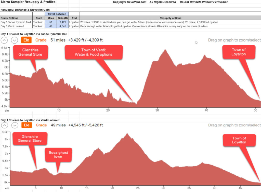
Route Options
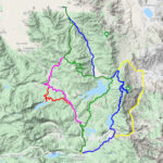
- Day 1 Tahoe Pyramid Trail (TPT)
- Start on a scenic bike path along the Truckee River and, then, do a quick jaunt through the Glenshire neighborhood.
- Hop on the Tahoe Pyramid Trail as it follows the Truckee River the rest of the way to Verdi, NV. This is a non-technical trail, but will require pushing your bike up/down some stairs. Towards the end, there are three steep sections that may look more enticing to walk than ride.
- Grab lunch in Verdi at the Sasquatch Tavern or just fill your water at the Crystal Peak Park. There is also a convenience store about 0.3 miles down the main road.
- Grind out the big climb up Dog Valley Road (gravel) and back into California. The climb out of Verdi can get pretty hot, so check the temperature forecasts and aim for doing the climb earlier in the day.
- The road that descends from the saddle can be a bit chunky, so watch your speed.
- Cruise into the beautiful Sardine Valley and then head north up a gentle grade to a saddle.
- You’ll start whizzing downhill on Smithneck road (gravel), but don’t miss the turnoff for the Loyalton trail.
- Once on the trail, enjoy about 4 miles of downhill singletrack (with only a few rocky sections) before dumping out in the Sierra Subdivision.
- As you coast down the road into Loyalton, enjoy the view looking across the Sierra Valley.
- Day 1 Verdi Lookout
- Start on a scenic bike path along the Truckee River and, then, do a quick jaunt through the Glenshire neighborhood.
- Cross over the Truckee River and take a 30-minute break checking out the ruins of Boca, a boom and bust town in the late 1800’s. There is a short 0.5 mile loop with signs that provide the history of the town.
- Cruise for a few miles along the Boca reservoir.
- Leave pavement and start climbing through the woods towards Verdi Peak. Towards the top, on the out-and-back stretch, the road gets a bit rocky in few, short sections and provides a good excuse to hop off and walk.
- At the top, eat lunch and enjoy the amazing views from the lookout.
- Heading down, pick your way carefully through the chunky sections. Back at the junction, the road conditions are good for the rest of the way to the intersection of Dog Valley Rd. Enjoy the views of the valley and several reservoirs.
- After turning on Dog Valley Rd, descent can get a bit chunky, so watch your speed.
- Cruise into the beautiful Sardine Valley and then head north up a gentle grade to a saddle.
- You’ll start whizzing downhill on Smithneck road (gravel), but don’t miss the turnoff for the Loyalton trail.
- Once on the trail, enjoy about 4 miles of fun, downhill singletrack (with only a few, short rocky sections) before dumping out in the Sierra Subdivision.
- As you coast down the road into Loyalton, enjoy the view looking across the Sierra Valley.
- Day 2 “Chill”
- Climb gently out of Loyalton and do a quick tour through the Sierra Subdivision.
- Transition to gravel and start a long climb up Bear Valley Rd. The grades are gentle, but the first section is exposed and can get hot. Check the temperature forecast and aim for starting the climb by late morning.
- After a few miles, you’ll find yourself among trees again and riding along a beautiful meadow.
- You’ll pass Bear Valley Campground, which has vault toilets. There is also a faucet, but you need to treat the water before drinking it.
- You then get a ripping descent, but be careful, it suddenly hits sections of washboard, which has claimed the lives of many water bottles. After you’ve checked that you still have our bottles, enjoy a level traverse with views of Lemon Valley.
- After crossing HWY 89 and a short section of pavement, you cross over an aqueduct, which is as great spot to take a break and filter water.
- The forest roads heading south can get pretty chunky and you’ll have to pick your way around exposed edges of rocks. Don’t worry, the road conditions improve, but there are a few more rough sections ahead. Thankfully, it’s mostly downhill.
- After a two quick crossings of HWY 89, you’ll start riding the Emigrant trail. It’s a non-technical trails with only a few short, punchy climbs.
- At the parking lot for the Donner Memorial Picnic Area, take a 20-minute break to walk your bike around the 0.5-mile loop that weaves through the area where the Donner family tried to survive a winter. Signs along the trail provide details on the tragedy they endured.
- A little more singletrack pops you into the Prosser Hill neighborhood. After a short section of pavement, you dive off the road to climb over the hill on a trail that parallels HWY 89.
- Enjoy a zig-zagging descent on a bike path and then head through a neighborhood. One more short stretch on a bike path and, then, you drop into downtown Truckee.
- Day 2 Independence Lake
- Climb gently out of Loyalton and do a quick tour through the Sierra Subdivision.
- Transition to gravel and start a long climb up Bear Valley Rd. The grades are gentle, but the first section is exposed and can get hot. Check the temperature forecast and aim for starting the climb by late morning.
- After a few miles, you’ll find yourself among trees again and riding along a beautiful meadow.
- You’ll pass Bear Valley Campground, which has vault toilets. There is also a faucet, but you need to treat the water before drinking it.
- You then get a ripping descent, but be careful, it suddenly hits sections of washboard, which has claimed the lives of many water bottles. After you’ve checked that you still have our bottles, enjoy a level traverse with views of Lemon Valley.
- After crossing HWY 89 and a short section of pavement, you cross over an aqueduct, which is as great spot to take a break and filter water.
- The forest roads heading south can get pretty chunky and you’ll have to pick your way around exposed edges of rocks.
- Turn off at the sign for Independence Lake and climb about 3 miles to the lake. Some sections of this road will have exposed rocks, but you can pick your way through them.
- Once at the lake, take a break and enjoy the amazing views and free boat rentals. There’s also a vault toilet. NO POTABLE WATER (filter from the lake)
- Backtrack a bit and then continue heading south. The next section of road has long stretches with exposed rocks. You’ll be able to pick you way through them, but you’ll need to watch your speed on the downhills because rocks are easily hidden in the shadows that are cast across the road.
- After a two quick crossings of HWY 89, you’ll start riding the Emigrant trail. It’s a non-technical trail with only a few short, punchy climbs.
- At the parking lot for the Donner Memorial Picnic Area, take a 20-minute break to walk your bike around the 0.5-mile loop that weaves through the area where the Donner family tried to survive a winter. Signs along the trail provide details on the tradegy they endured.
- A little more singletrack pops you into the Prosser Hill neighborhood. After a short section of pavement, you dive off the road to climb over the hill on a trail that parallels HWY 89.
- Enjoy a zig-zagging descent on a bike path and then head through a neighborhood. One more short stretch on a bike and, then, you drop into downtown Truckee.
- Day 2 Sardine Lookout
- Climb gently out of Loyalton and do a quick tour through the Sierra Subdivision.
- Transition to gravel and start a long climb up Bear Valley Rd. The grades are gentle, but the first section is exposed and can get hot. Check the temperature forecast and aim for starting the climb by late morning.
- After a few miles, you’ll find yourself among trees again and riding along a beautiful meadow.
- You’ll make a turn at Bear Valley Campground, which has vault toilets. There is also a faucet, but you need to treat the water before drinking it.
- Continue climbing to the shoulder of Sardine Mountain. As you get higher, the road deteriorates, but you can usually weave between the larger rocks. You’ll finally reach a gate, which you can walk your bike around. The lookout is just a short, steep stretch up the road.
- Take a break and grab a bite to each, while enjoying the spectacular views from the lookout.
- You’ll descend down the mountain on a road with switchbacks and lots of rocks. Again, you can ride between the rocks, but you’ll need to check your speed on the descent.
- Roll into Sardine Valley and then hop on a stretch of pavement with views of Stampede Reservoir. Top up your water at the at the picnic area next to the lake.
- Exit the pavement to hop on the first section of the Emigrant trail. You’ll ride about 8 miles of non-technical singltrack before reaching a parking lot.
- After a very short ride on HWY 89, you’ll pick up the next section of the Emigrant trail.
- At the parking lot for the Donner Memorial Picnic Area, take a 20-minute break to walk your bike around the 0.5-mile loop that weaves through the area where the Donner family tried to survive a winter. Signs along the trail provide details on the hardships they endured.
- A little more singletrack pops you into the Prosser Hill neighborhood. After a short section of pavement, you dive off the road to climb over the hill on a trail that parallels HWY 89.
- Enjoy a zig-zagging descent on a bike path and then head through a neighborhood. One more short stretch on a bike and, then, you drop into downtown Truckee.
Getting to Truckee
Drive: If you are coming from Sacramento or the Bay Area, be aware that traffic Friday afternoon/evening is notoriously bad.
Amtrak: Amtrak has 2 trains that stop in Truckee each day (1 from the east and 1 from the west). Amtrak has reportedly become more bike friendly, but be sure to check out the details at amtrak.com. According to their booking system, they don’t “officially” let you book a bike to Truckee. The issue is that they don’t have access to the luggage car that holds your bike when they stop in Truckee. The platform is too short. However, some cyclists have had success with the following: Talk to a conductor when you get on the train and explain you want to get off in Truckee with your bike. They can move your bike to a luggage closet. That way, when they stop in Truckee, they can get your bike off the train. Worst case, you can always get off with your bike in Reno. There is a good bike route from Reno to Truckee, but can be hot in summer.
Bus: Greyhound and Amtrak (offers bus routes to Truckee) are your bus options.
Fly: Reno is the closest airport (~45 min drive) and an Uber to Truckee from RNO is about $65 (may change). After that, Sacramento is your next closest option (~90 min drive).
Staying in Truckee
Rent a house: There are lot of homes for rent in Truckee and the Tahoe Donner neighborhood. You can often get a 3 bedroom home for around $200/night through AirBnB or VRBO.
Hotel or hostel: There are a few hotels in Truckee and one hostel (~$50 for a bed in a bunk room).
Warmshowers.org: A great community of cyclists who host traveling cyclists. There are about 10 hosts in Truckee. The spirit of the site is that they host cyclists when they are actually on a trip, but some hosts might be willing to let you stay a night and leave your car parked in front of their house.
Camping: There are several campgrounds in/near Truckee. Donner State Park is the closest to the downtown. After that, your options are Tahoe Donner’s Campground , Granite Flat Campground, or Lakeside Campground.
Supplies
Groceries: Truckee has a Safeway, Grocery Outlet, Save Mart, and New Moon (a natural foods market)
Bike shop: Truckee has a few bike shops, but we’d recommend Start Haus and Paco’s
Outdoor equipment: The Ace Hardware has lots of outdoor equipment and there several other outdoor shops
Where to Leave Your Car
Officially, there is no long-term parking in Truckee. All public roads have a 72-hour limit and, around the historic downtown, it’s more restrictive with meters. In the summer, outside of the historic downtown, the police are unlikely enforce the 72-hour limit, so you should be OK to leave your car for 5-7 days before you’d risk getting a ticket. Just don’t park in a business parking lot or block a driveway. If someone reports your car abandoned, then the 72-hour clock starts ticking.
If you stay in a hotel, ask if you can leave your car on their property.