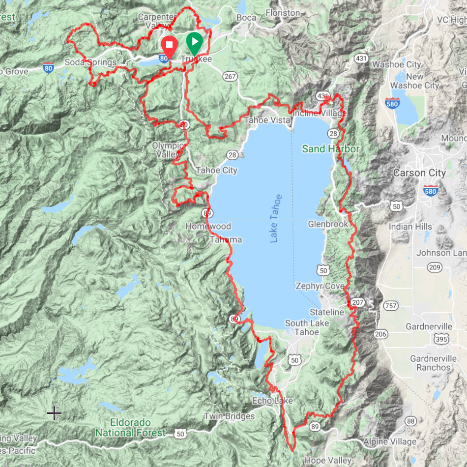
Route Tracks, Waypoints, and GPX File
Your route is hosted on Ride With GPS.
IMPORTANT: The name in your Ride With GPS account needs match the name you used to purchase your Guide Pack.
To navigate the route:
- Use your phone with the Ride With GPS app or
- Download the GPX file to your GPS device.
Two alternative tracks are included for making the Bones Loop shorter:
- DLRT Alternative: Head straight out of Truckee up Donner Lake Rim Trail towards Donner Pass. This alternative skips the initial part of the Bones loop that tours through the area that the Donner Party tried to winter. This alternative cuts out 12 miles and 600ft of elevation gain.
- Boreal Alternative: Skip the Hole In the Ground (HITG) trail. This alternative avoids the more technically-demanding HITG trail. Some people love that trail; others don’t. You’ll reach your first resupply in Soda Springs 2-3 hours faster with this shortcut. This alternative cuts out 9.4 miles and 1,370ft of elevation gain.
Route Resupply Notes & Profiles
This document gives you a preview of the route and helps you determine how much water and food to carry between resupply points.
The more miles and elevation gain to the next resupply, the more water and food you should carry.
Regarding water sources, the profiles point out only the most reliable sources. In a typical year, there are additional sources, but they could be dry if it was a low-snowpack year.
Print and bring a copy it with you for quick reference during your ride. You will refer to it often.

Member Forum
Post your questions or requests regarding any of the Bones to Blue routes in the Member Forum.
Accommodation Options
These are only suggestions. If they don’t work for your trip, feel free make your own plans.
Wild camping is allowed in National Forests, however, check alerts and notifications for closures and fire bans:
- Alerts and Notifications for: Tahoe National Forest and Lake Tahoe Basin Management Unit (click links)
If you plan to have a campfire, get a campfire permit and bring a copy of it with you.
Also, only a few campgrounds have bear boxes. Therefore, you’ll need to an Ursack or another effective bear/food strategy. Do not leave food out. It leads to bears loosing their fear of humans and, later, being killed.
3 nights / 4 days option for full Bones to Blue Route
- A four-day pace is not easy and requires fitness, early-morning starts, and long days in the saddle.
- Day 1: 62 miles | 6,400 ft
- Day 2: 56 miles | 7,300 ft
- Day 3: 70 miles | 9,900 ft
- Day 4: 65 miles | 8,000 ft
- Night 1: Donner Lake Memorial Campground
- After you finish descending the “Jackass” trail, you’ll be in Truckee. Stock up on food from the local grocery stores or restaurants (plenty of options near the route) and head west on Donner Pass Road to Donner Lake Memorial Campground.
- It’s open Memorial Day to Labor Day and the gate station is open until 5pm.
- Pay the camping fee at the gate station and find out which site is designated for bikers. They will do their best to give you a spot without any reservation.
- Camping facilities: Special (lower) fee for hiker/biker camping, toilets, sinks, coin showers, bear boxes, potable water
- Night 2: North Canyon Campground or rent a cabin
- Stock up on food in Incline Village before climbing up to the Incline Flume Trail
- Marlette Lake is beautiful, but camping around the lake is prohibited. Climb out of the lake basin for several camping options before reaching Spooner Lake.
- As you being to descend on North Canyon road (dirt), you’ll pass the following camping options (in this order): North Canyon walk-in Campground, Wildcat Cabin, and Spooner Lake Cabin.
- North Canyon Campground is a walk-in campground (no reservations or fees): vault toilet, bear boxes, and a nearby creek for filtering water (.25 miles south of the campground).
- Alternatively, you can rent either of the simple cabins that are maintained by the Nevada Parks. Email: [email protected] to check availability and current rate ($65).
- Both cabins can sleep up to 4 people inside (a little snug) and there are flat spots around the cabin for others to pitch their tents. They both have a composting toilet and are stocked with 10 gallons of water. You’ll get a code for entering the cabin after you reserve it.
- Night 3: Fallen Leaf Lake Campground
- The state of Nevada campgrounds have a “no turn away” policy for hikers/bikers and will try to accommodate you even if the campground is fully booked. Inquire at the gate about available hiker/biker spots and the nightly rate.
- Facilities: Coin showers, bathrooms, potable water, and bear boxes. They also have a few yurts for rent.
1 night / 2 days option for just the Bones Loop
- This is a great overnight loop for a 2-day weekend ride.
- Day 1: 31 miles | 4,200 ft
- Day 2: 31 miles | 2,300 ft
- Night 1: Sand Ridge Lake
- This small, pristine, swimmable lake is about 0.25 miles off of the Hole In the Ground Trail (almost exactly halfway into the Bones Loop).
- There are no campground facilities, but there are obvious spots for making camp. Please be sure to bear-proof your food (e.g., Ursack) and go to the bathroom at least 100 feet from the lake. Depending on the time of year, it can be buggy, so bring bug spray and clothes to cover up with during the evening.